Capabilities
One capture. The whole envelope.
Commission a single drone inspection and the data feeds compliance, planned maintenance and the board pack at once. Six outputs, one flight, no scaffold.
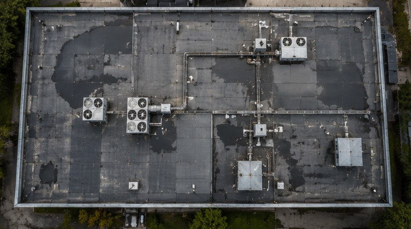
Roof & building envelope inspection
A drone roof inspection captures flat roofs, pitched systems, membranes, upstands, outlets and drainage at high resolution, with nobody working at height. You get the condition of the whole roof, not the corners anyone could safely reach.
- Membrane condition, splits, blistering and lap failures, located by bay
- Ponding and drainage performance, mapped across the roof
- Flashings, upstands and penetrations, graded for risk
- Plant, walkways and fall-arrest condition where present
Facade & external wall inspection
Elevation-by-elevation condition of cladding, render, brickwork, sealant, balconies and movement joints, captured close-up by drone. The imagery supports a fire risk appraisal of external walls under PAS 9980 and the EWS process, and flags water ingress paths before they reach the inside.
- Cladding, render and brick condition at full height
- Cracking, spalling, displacement and failed sealant
- Visual evidence to support FRAEW and EWS1 decisions
- Balcony, soffit and parapet condition
Thermal imaging & moisture inspection
Radiometric thermal capture surfaces what visual inspection cannot: anomalies that can point to trapped moisture, wet or missing insulation, air leakage and heat loss. Anomalies are flagged for investigation rather than prescribed as a diagnosis.
- Subsurface moisture indicators in flat roofs and walls
- Insulation gaps, cold bridges and wet-insulation signatures
- Air leakage and heat-loss anomalies
- Early evidence to direct damp and mould investigations
AI-assisted defect analysis, human-validated
A single capture can run to thousands of images. The Ovrsite AI engine detects, measures and grades defects across the full set rather than a sample, then our team validates every finding and removes false positives. Speed from the machine, judgement from people. Purpose-built computer-vision detection, not a repurposed language model.
- Full-coverage detection, not spot sampling
- Consistent grading on one risk scale
- Every finding human-validated before it reaches you
- Findings located on the asset, not just described
RICS-aligned reporting & CAPEX forecasting
Findings become a report your advisors, lenders and board already know how to read, then a costed and time-phased CAPEX plan. Worst risk first, safe deferrals justified, every pound traceable to a dated finding.
- Reporting written to RICS-aligned conventions
- Costed, prioritised, multi-year CAPEX forecast
- Deferral logic you can defend to a board
- Outputs that export to your asset and finance systems
Golden Thread & building safety evidence
For higher-risk buildings, condition data is part of a legal duty. Ovrsite produces dated, located, structured records that feed the Golden Thread of information and the building safety case, and stay current in Atlas across the life of the building.
- Structured, digital condition records, dated and located
- Evidence aligned to the building safety case
- Ready for the Building Safety Regulator on request
- Handover-ready when an accountable person changes
Ovrsite vs a traditional access-based inspection
The same goal, condition you can trust and defend, reached a very different way.
| Ovrsite | Traditional access / scaffold | |
|---|---|---|
| Coverage | The whole envelope, every elevation at high resolution | Sampled where a person can safely reach |
| Working at height | None. Captured from the air | Scaffold, MEWP or rope access |
| Time on site | Hours, no scaffold, no closures | Days to weeks, plus access and disruption |
| Analysis | AI detection across every image, human-validated | One inspector's judgement on the day |
| Output | Graded, located, dated findings in Atlas, plus a costed CAPEX plan | A written report |
| The record over time | Stays live in Atlas, current between visits | A static document, dated on delivery |
| Cost and disruption | Typically 60-70% less than scaffold-based access | Scaffold, access and closure costs |
| Regulatory evidence | Golden Thread-ready, timestamped and defensible | Varies by provider |
Services, answered
Most single buildings are captured in hours, not days, with no scaffold to erect and no closures. Flight time depends on size, height and airspace. Larger estates are planned as a programme.
Rarely. Drone capture avoids most of the access, scaffold and disruption a traditional inspection needs. Where airspace or proximity rules apply, we plan and obtain the permissions.
Graded findings in Atlas, a RICS-aligned report, the underlying imagery, and a costed CAPEX plan. You can act on it, defend it, and export it.
Yes. Many clients use Ovrsite as the independent capture and analysis layer and keep their own people on interpretation and delivery.
One flight. Six outputs.
Commission an inspection on one building and see the whole envelope graded, costed and ready to defend.